WRF Namelist.Input
&time_control
run_days = 0,
run_hours = 84,
run_minutes = 0,
run_seconds = 0,
start_year = 2017, 2017, 2017,
start_month = 4, 4, 4,
start_day = 14, 14, 14,
start_hour = 0, 0, 0,
start_minute = 0, 0, 0,
start_second = 0, 0, 0,
end_year = 2017, 2017, 2017,
end_month = 4, 4, 4,
end_day = 17, 17, 17,
end_hour = 0, 0, 0,
end_minute = 0, 0, 0,
end_second = 0, 0, 0,
interval_seconds = 10800,
input_from_file = .true., .true., .true.,
history_interval = 60, 60, 60,
frames_per_outfile = 1, 1, 1,
restart = .false.,
restart_interval = 5000,
io_form_history = 2,
io_form_restart = 2,
io_form_input = 2,
io_form_boundary = 2,
debug_level = 100,
adjust_output_times = .true.,
/
&domains
time_step = 180,
time_step_fract_num = 0,
time_step_fract_den = 1,
max_dom = 3,
e_we = 121, 160, 157,
e_sn = 91, 121, 118,
e_vert = 40, 40, 40,
p_top_requested = 10000,
num_metgrid_levels = 32,
num_metgrid_soil_levels = 4,
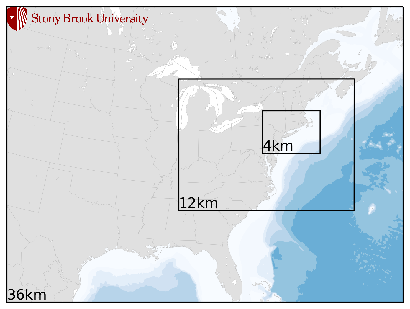
dx = 36000, 12000, 4000,
dy = 36000, 12000, 4000,
grid_id = 1, 2, 3,
parent_id = 1, 1, 2,
i_parent_start = 1, 53, 77,
j_parent_start = 1, 29, 53,
parent_grid_ratio = 1, 3, 3,
parent_time_step_ratio = 1, 3, 3,
feedback = 0,
smooth_option = 0,
use_adaptive_time_step = .true.,
step_to_output_time = .true.,
target_cfl = 1.2, 1.2, 1.2,
target_hcfl = 0.84, 0.84, 0.84,
max_step_increase_pct = 5, 51, 51,
starting_time_step = -1, -1, -1,
max_time_step = -1, -1, -1,
min_time_step = -1, -1, -1,
adaptation_domain = 1,
/
&physics
mp_physics = 8, 8, 8,
ra_lw_physics = 1, 1, 1,
ra_sw_physics = 4, 4, 4,
radt = 30, 15, 5,
sf_sfclay_physics = 5, 5, 5,
sf_surface_physics = 2, 2, 2,
bl_pbl_physics = 5, 5, 5,
bldt = 0, 0, 0,
cu_physics = 5, 5, 0,
cudt = 0, 0, 0,
ishallow = 1,
isfflx = 1,
ifsnow = 1,
icloud = 1,
surface_input_source = 1,
num_soil_layers = 4,
num_land_cat = 21,
sf_urban_physics = 0, 0, 0,
maxiens = 1,
maxens = 3,
maxens2 = 3,
maxens3 = 16,
ensdim = 144,
fractional_seaice = 0,
seaice_threshold = 100.,
do_radar_ref = 1,
/
&fdda
/
&dynamics
rk_ord = 3,
diff_6th_opt = 2,
diff_6th_factor = 0.12,
w_damping = 1,
diff_opt = 1, 1, 1,
km_opt = 4, 4, 4,
damp_opt = 3,
base_temp = 290.,
iso_temp = 210.,
zdamp = 5000., 5000., 5000.,
dampcoef = 0., 0., 0.,
khdif = 0, 0, 0,
kvdif = 0, 0, 0,
smdiv = 0.1, 0.1, 0.1,
emdiv = 0.01, 0.01, 0.01,
epssm = 0.1, 0.1, 0.1,
non_hydrostatic = .true., .true., .true.,
time_step_sound = 0, 0, 0,
h_mom_adv_order = 5, 5, 5,
v_mom_adv_order = 3, 3, 3,
h_sca_adv_order = 5, 5, 5,
v_sca_adv_order = 3, 3, 3,
moist_adv_opt = 1, 1, 1,
scalar_adv_opt = 1, 1, 1,
/
&bdy_control
spec_bdy_width = 5,
spec_zone = 1,
relax_zone = 4,
specified = .true., .false., .false.,
nested = .false., .true., .true.,
/
&grib2
/
&namelist_quilt
nio_tasks_per_group = 0,
nio_groups = 1,
/